


aveyronnaise 2013

frank12
User
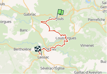

Length
22 km

Max alt
660 m

Uphill gradient
417 m
Km-Effort
27 km

Min alt
549 m

Downhill gradient
414 m
Boucle
No
Creation date :
2014-12-10 00:00:00.0
Updated on :
2014-12-10 00:00:00.0
30m
Difficulty : Unknown

FREE GPS app for hiking
 SityTrail
IGN / Geographical institutes
SityTrail Plus
The world is yours!
About
Trail Other activity of 22 km to be discovered at Occitania, Aveyron, Palmas d'Aveyron. This trail is proposed by frank12.
Description
cruejouls laissac
Positioning
Country:
France
Region :
Occitania
Department/Province :
Aveyron
Municipality :
Palmas d'Aveyron
Location:
Unknown
Start:(Dec)
Start:(UTM)
488485 ; 4921289 (31T) N.
Comments